
As many South Carolina municipalities experience stronger and more frequent flooding, cities are fighting back with everything from improved drainage systems to development regulations that anticipate future climate changes.
When Hurricane Florence drenched South Carolina in 2018, Conway took a particularly hard hit, with some homes and structures submerged in contaminated water for three weeks or more. Conway also experienced major floods in 2016, 2015, 1999 and 1928, City Administrator Adam Emrick said.
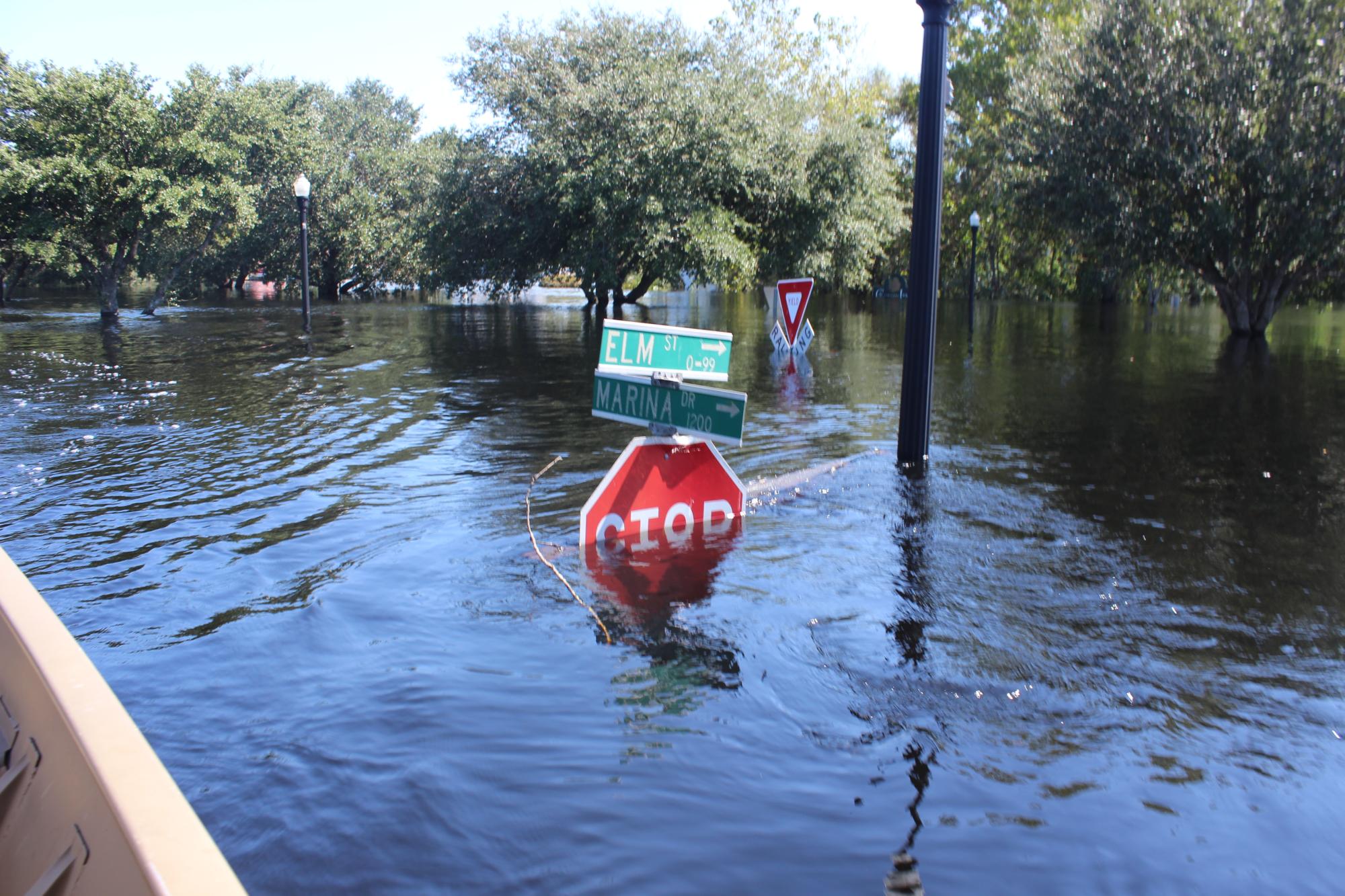
As a river town near the coast, Conway's periodic experiences with floods have contributed to
projects and land use changes designed to make it more flood-resilient. Photo: City of Conway.
“Each of these flood events typically involved two distinct flooding periods — flash flooding during or just after the rain event that lasts a few days, and riverine flooding, which may come days after the event and last for weeks,” Emrick said. “Hurricane Florence in 2018 was the worst flood on record, damaging hundreds of homes and businesses.”
In the years since, Conway has made flood mitigation the top priority in this city along the banks of the Waccamaw River, 12 miles inland from the coast.
“We can't stop the rain, but we will do everything within our power to ensure that the water that falls on our city can make its way to the sea without disrupting the lives of our citizens,” Mayor Barbara Jo Blain said.
Some of the projects undertaken in Conway include Federal Emergency Management Agency buyouts of flood-prone properties, acquisition of conservation property, increased elevation requirements, resiliency and stormwater master plans, tree plantings in flood-sensitive areas and changes to Riverfront Park, said Mary Catherine Hyman, Conway’s deputy city administrator.
“Conway recognizes that certain threats are out of its control, but the city has chosen to use every available tool in its toolbox,” Hyman said. “Every decision, including capital projects and land use, is made with flooding in mind.”
At Conway’s Riverfront Park, for example, cypress trees were planted to replace the riprap shoreline, electrical systems were adjusted, the tennis center and fireman’s clubhouse were removed, and the riverwalk surface itself was rebuilt with better, more water-tolerant wood.
The city also took steps to create an artificial Carolina Bay similar to the natural oval-shaped depressions that are considered isolated freshwater wetlands. Kevin Chestnut, the city’s former public works director, proposed the idea for an area where FEMA funds had been used to buy out properties subject to repetitive flooding.
Chestnut’s idea led to a partnership with The Nature Conservancy to bring in a nature-based engineering firm that proposed converting the areas into a shallow stormwater detention-retention area, mimicking wetlands, she said. Called Chestnut Bay, the city is turning the surrounding land into a community park.
In Charleston, flooding issues are exacerbated by the historic city’s geography, coupled with the climate shift in the past decade that has brought increased hurricanes and extreme tides. The city has responded with everything from massive tunnels to move water out of the peninsula to rewriting regulations to ensure new development and redevelopment is done with an understanding of climate change.
“A lot of the peninsula is flat and low-lying. There’s not a lot of elevation change to push water out toward the coast, and there aren’t creeks or rivers that run through most of the downtown area,” said Matthew Fountain, Charleston’s director of stormwater management. “So the challenge you have is trying to get water to flow through a traditional drainage system out to the harbor or into the Ashley River.”
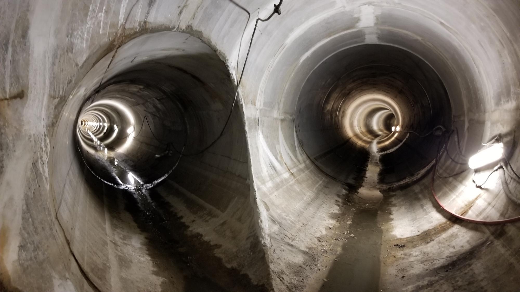
Two stormwater drainage tunnels intersect in Charleston's deep tunnel system.
Photo: City of Charleston.
Charleston’s flat land requires larger pipes and pumping stations since there isn’t enough slope to cause gravity to move the water quickly. And because Charleston is a historic city with extensive development and infrastructure beneath its streets, a deep tunnel system, drilled to about 130 feet below ground is being used in some parts of the city.
Charleston has two major tunnel and pump systems downtown, including an older project that had some recent expansion that serves the Market Street area, Calhoun Street and parts of the peninsula. The city also recently finished building tunnels and is now working on a pump station in the U.S. Highway 17-Septima Clark Parkway areas. During a severe rainstorm, the areas will still experience street flooding, but the water in these areas now drains more quickly than other parts of the city, Fountain said.
And while capital projects play a big role in addressing flooding, in 2020 the city also reworked its stormwater regulations for new development and redevelopment projects to make sure the unique water control challenges of Charleston are considered.
Fountain stressed the importance of setting up the capital project and redevelopment regulations to look at future conditions, with a realistic chance of 2 feet of sea level rise in Charleston in the next 50 years.
“That has huge value,” he said. “If you want your city to continue to function in the future, make sure when you’re doing your design work, you’re designing it for those future conditions instead of spending a whole bunch of money building something that will not work in 30 or 40 years.”
Fountain said the standards are not anti-development. In fact, if regulations are written correctly, new development can actually help with stormwater and infrastructure issues.
Beaufort is another coastal city that has dealt with increasing storms and sea level rise. The city has tried to look ahead by commissioning stormwater studies, starting with some of its most vulnerable areas, said John “JJ” Sauvé, Beaufort’s assistant city manager.
“Much of the stormwater issues faced on a day-to-day basis could be described as nuisance waters, i.e., standing water on streets, paths and sidewalks, but these nuisance waters are generally a sign of a greater problem,” Sauvé said. “Commissioned studies have shown aging or aged-out stormwater pipes, collapsed pipes, dead-end pipes and pipes too small to carry current stormwater runoff. Because of the age of many of these pipes, maintenance is difficult and recurring problems occur at every significant rainfall event.”
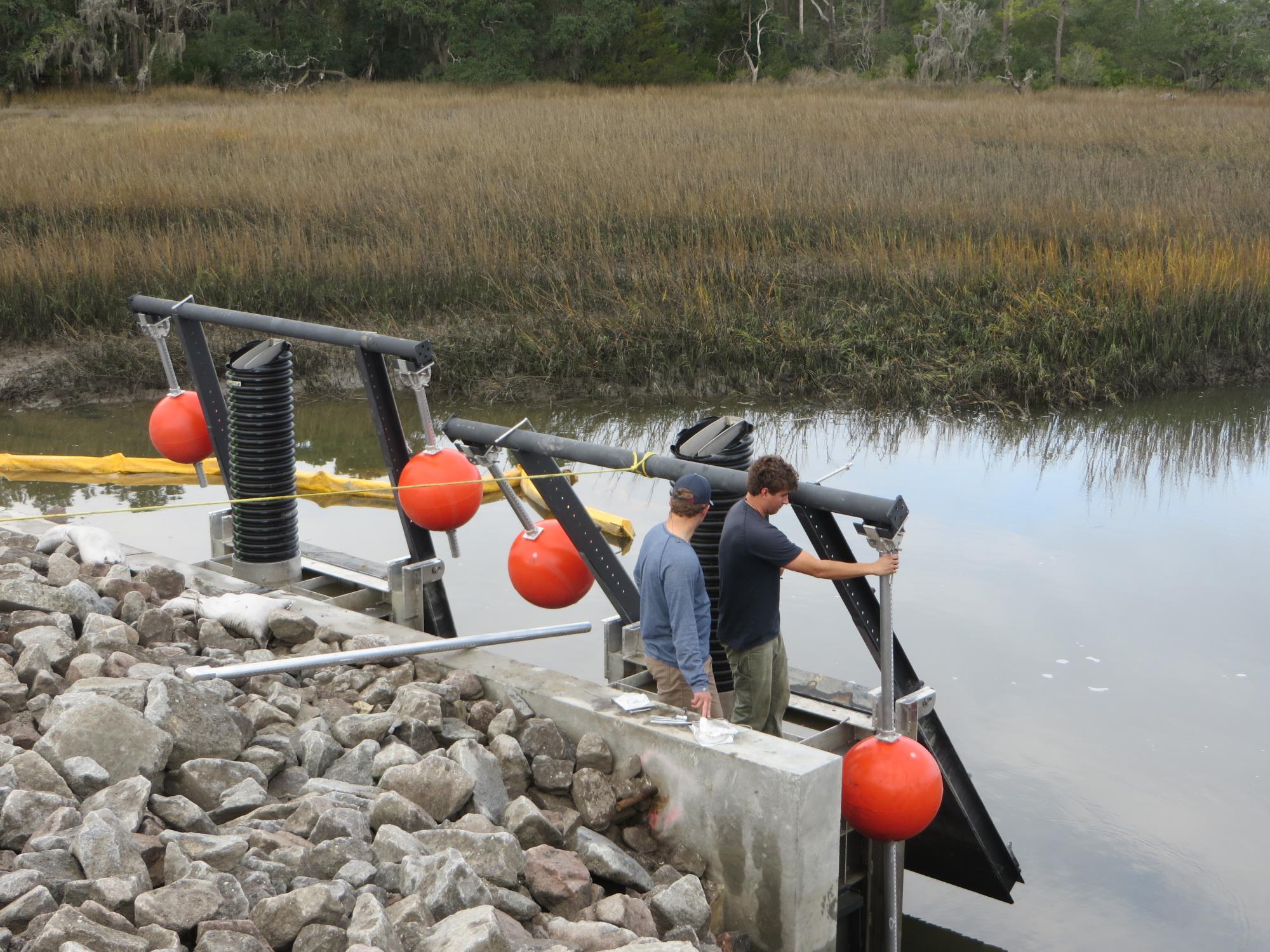
Beaufort's Mossy Oaks stormwater drainage project included tidal flap gates that can
control water flow into the marsh. Photo: City of Beaufort.
One example of the city’s work is in the Mossy Oaks neighborhood, an area of about 550 acres and several hundred homes that flooded after heavy rains, high tides or storm surges. After a multijurisdictional task force was formed in 2017, an engineering study identified factors such as inefficient drainage structures and poor drainage patterns. Other issues included homes built on slabs and overgrown vegetation in ditches.
The $8 million Mossy Oaks stormwater project was completed in April 2021 and has been “a success for the community, public safety responders, public works maintenance teams and homeowners in the area,” Sauvé said.
Several other stormwater projects are currently in design or planning stages.
“These projects taken together are intended to give the city a full assessment of and understanding of our current stormwater infrastructure across the city, so that we can continue to address known issues and prevent issues through responsible infrastructure replacement and maintenance,” he said.
The biggest lesson Beaufort learned is the importance of assessing and understanding stormwater systems.
“If you know there is a problem area, find out why there is a problem. It could be a simple fix such as a clogged drain, or it could be as complex as an aged-out piping system, but until you have a full understanding of your infrastructure, you’ll never know the extent of the issue,” Sauvé said. “We must utilize the resources we have such as grant funding and technology. For us one of the key pieces of our long-term planning has been the ongoing process of building out a municipal GIS system to keep track of, among many other things, our critical stormwater infrastructure and to provide council with accurate and up-to-date information.”